
Faça uma doação
Prepare-se para a sua próxima aventura:
Como Associado da Amazon, este site recebe uma comissão sobre compras elegíveis sem custo adicional para si.
Mapa topográfico Roggan River
Clique no mapa para exibir a altitude.
Faça uma doação
Prepare-se para a sua próxima aventura:
Como Associado da Amazon, este site recebe uma comissão sobre compras elegíveis sem custo adicional para si.
Sobre este mapa
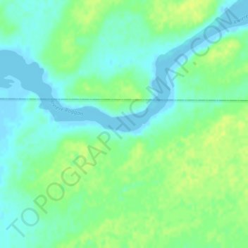
Nome: Mapa topográfico Roggan River, altitude, relevo.
Local: Roggan River, Eeyou Istchee, Northern Quebec, Quebec, Canada (54.39612 -79.44455 54.41612 -79.42455)
Altitude média: 8 m
Altitude mínima: -5 m
Altitude máxima: 16 m
Faça uma doação
Prepare-se para a sua próxima aventura:
Como Associado da Amazon, este site recebe uma comissão sobre compras elegíveis sem custo adicional para si.
Outros mapas topográficos
Clique em um mapa para visualizar sua topografia, sua altitude e seu relevo.
Whapmagoostui (Category I Land)
Canada > Quebec > Eeyou Istchee > Whapmagoostui (Village)
Altitude média: 91 m
Faça uma doação
Prepare-se para a sua próxima aventura:
Como Associado da Amazon, este site recebe uma comissão sobre compras elegíveis sem custo adicional para si.