
Mapa topográfico Petrothalassa
Mapa interativo
Clique no mapa para exibir a altitude.
Sobre este mapa
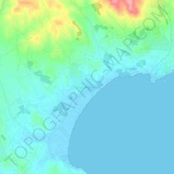
Nome: Mapa topográfico Petrothalassa, altitude, relevo.
Altitude média: 24 m
Altitude mínima: -4 m
Altitude máxima: 131 m
Outros mapas topográficos
Clique em um mapa para visualizar sua topografia, sua altitude e seu relevo.
Δορούφι Κοιλάδος
Greece > Peloponnese, Western Greece and the Ionian > Argolis Regional Unit > Municipal Unit of Kranidi
Δορούφι Κοιλάδος, Κοινότητα Κοιλάδος, Municipal Unit of Kranidi, Municipality of Ermionida, Argolis Regional Unit, Peloponnese Region, Peloponnese, Western Greece and the Ionian, 213 00, Greece
Altitude média: 30 m
Portocheli
Greece > Peloponnese, Western Greece and the Ionian > Argolis Regional Unit > Municipal Unit of Kranidi
Portocheli, Municipal Unit of Kranidi, Municipality of Ermionida, Argolis Regional Unit, Peloponnese Region, Peloponnese, Western Greece and the Ionian, 213 00, Greece
Altitude média: 19 m
Kranidi
Greece > Peloponnese, Western Greece and the Ionian > Argolis Regional Unit > Municipal Unit of Kranidi
Kranidi, Municipal Unit of Kranidi, Municipality of Ermionida, Argolis Regional Unit, Peloponnese Region, Peloponnese, Western Greece and the Ionian, 213 00, Greece
Altitude média: 77 m