
Mapa topográfico Δορούφι Κοιλάδος
Mapa interativo
Clique no mapa para exibir a altitude.
Sobre este mapa
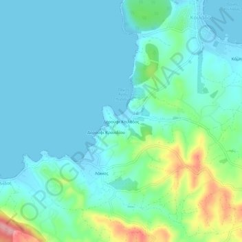
Nome: Mapa topográfico Δορούφι Κοιλάδος, altitude, relevo.
Altitude média: 30 m
Altitude mínima: -2 m
Altitude máxima: 149 m
Outros mapas topográficos
Clique em um mapa para visualizar sua topografia, sua altitude e seu relevo.
Petrothalassa
Greece > Peloponnese, Western Greece and the Ionian > Argolis Regional Unit > Municipal Unit of Kranidi
Petrothalassa, Municipal Unit of Kranidi, Municipality of Ermionida, Argolis Regional Unit, Peloponnese Region, Peloponnese, Western Greece and the Ionian, 213 00, Greece
Altitude média: 24 m
Portocheli
Greece > Peloponnese, Western Greece and the Ionian > Argolis Regional Unit > Municipal Unit of Kranidi
Portocheli, Municipal Unit of Kranidi, Municipality of Ermionida, Argolis Regional Unit, Peloponnese Region, Peloponnese, Western Greece and the Ionian, 213 00, Greece
Altitude média: 19 m
Kranidi
Greece > Peloponnese, Western Greece and the Ionian > Argolis Regional Unit > Municipal Unit of Kranidi
Kranidi, Municipal Unit of Kranidi, Municipality of Ermionida, Argolis Regional Unit, Peloponnese Region, Peloponnese, Western Greece and the Ionian, 213 00, Greece
Altitude média: 77 m