
Mapa topográfico State College
Mapa interativo
Clique no mapa para exibir a altitude.
Sobre este mapa
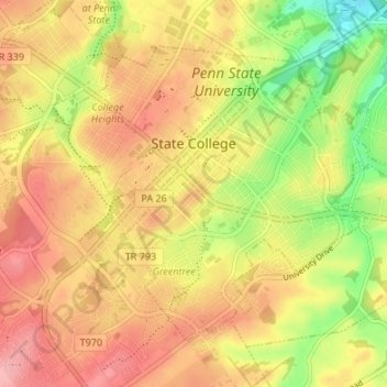
Nome: Mapa topográfico State College, altitude, relevo.
Local: State College, Centre County, Pennsylvania, United States (40.76837 -77.88617 40.80723 -77.81900)
Altitude média: 351 m
Altitude mínima: 286 m
Altitude máxima: 398 m
State College is situated at an elevation of approximately 1,200 feet (370 m) above sea level. According to the U.S. Census Bureau, the borough has a total area of 4.5 square miles (12 km2), all of it land. It is surrounded by large tracts of farmland, and an expanse of Appalachian Mountain ranges and forests. Its location within a valley makes it prone to frequent rain and snowfall. Nittany Mountain is part of Pennsylvania's geologic ridge-and-valley province of the Appalachian Mountains. It is (approximately) the geographic center of Pennsylvania.
Outros mapas topográficos
Clique em um mapa para visualizar sua topografia, sua altitude e seu relevo.
Bald Eagle State Park
United States > Pennsylvania > Centre County
Bald Eagle State Park, Howard Township, Centre County, Pennsylvania, 16841, United States
Altitude média: 290 m
Snow Shoe
United States > Pennsylvania > Centre County
Snow Shoe, Centre County, Pennsylvania, 16874, United States
Altitude média: 511 m
Poe Valley State Park
United States > Pennsylvania > Centre County
Poe Valley State Park, Little Poe Trail, Penn Township, Centre County, Pennsylvania, 16832, United States
Altitude média: 501 m