
Mapa topográfico Bald Eagle State Park
Mapa interativo
Clique no mapa para exibir a altitude.
Sobre este mapa
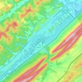
Nome: Mapa topográfico Bald Eagle State Park, altitude, relevo.
Altitude média: 290 m
Altitude mínima: 174 m
Altitude máxima: 525 m
Foster Joseph Sayers Reservoir is a 1,730-acre (700 ha) reservoir that was built in 1971 by the U.S. Army Corps of Engineers as part of a flood control project on the Susquehanna River basin. The lake was created by damming Bald Eagle Creek. It stretches upstream for 8 miles (12.87 km) and has 23 miles (37.01 km) of shoreline. The park is at an elevation of 958 feet (292 m).[1]
Outros mapas topográficos
Clique em um mapa para visualizar sua topografia, sua altitude e seu relevo.
State College
United States > Pennsylvania > Centre County
State College, Centre County, Pennsylvania, United States
Altitude média: 351 m
Snow Shoe
United States > Pennsylvania > Centre County
Snow Shoe, Centre County, Pennsylvania, 16874, United States
Altitude média: 511 m
Poe Valley State Park
United States > Pennsylvania > Centre County
Poe Valley State Park, Little Poe Trail, Penn Township, Centre County, Pennsylvania, 16832, United States
Altitude média: 501 m