
Mapa topográfico Postling
Mapa interativo
Clique no mapa para exibir a altitude.
Sobre este mapa
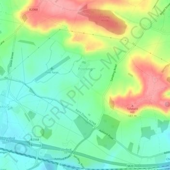
Nome: Mapa topográfico Postling, altitude, relevo.
Local: Postling, Folkestone and Hythe, Kent, Angleterre, Royaume-Uni (51.09089 1.04158 51.12235 1.08301)
Altitude média: 112 m
Altitude mínima: 68 m
Altitude máxima: 185 m
Outros mapas topográficos
Clique em um mapa para visualizar sua topografia, sua altitude e seu relevo.
Folkestone
Royaume-Uni > Angleterre > Kent > Folkestone and Hythe
Folkestone, Folkestone and Hythe, Kent, Angleterre, Royaume-Uni
Altitude média: 62 m
Dymchurch
Royaume-Uni > Angleterre > Kent > Folkestone and Hythe
Dymchurch, Folkestone and Hythe, Kent, Angleterre, Royaume-Uni
Altitude média: 1 m