
Mapa topográfico Wytheville
Mapa interativo
Clique no mapa para exibir a altitude.
Sobre este mapa
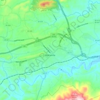
Nome: Mapa topográfico Wytheville, altitude, relevo.
Local: Wytheville, Wythe County, Virginia, 24382, United States (36.92258 -81.13589 36.98165 -81.03117)
Altitude média: 720 m
Altitude mínima: 621 m
Altitude máxima: 1059 m
Due to its elevation, the climate of Wytheville is either classified as mountain temperate or humid subtropical (Köppen Cfb or Cfa, respectively), and the town straddles the border between USDA Plant Hardiness Zones 6B and 7A. Summers are warm and humid, although significantly cooler than low-elevation places within the state, with only 4.6 days of 90 °F (32 °C)+ highs annually, and winters are generally cool to cold with occasional intervening warm periods and 11 nights of sub-10 °F (−12 °C) lows. Monthly mean temperatures range from 32.9 °F (0.5 °C) in January to 71.7 °F (22.1 °C) in July. Snowfall averages 20.5 inches (52 cm) per season and generally occurs from December to March.
Outros mapas topográficos
Clique em um mapa para visualizar sua topografia, sua altitude e seu relevo.
Austinville
United States > Virginia > Wythe County
Austinville, Wythe County, Virginia, 24312, United States
Altitude média: 645 m
Ivanhoe
United States > Virginia > Wythe County
Ivanhoe, Wythe County, Virginia, 24350, United States
Altitude média: 643 m
Cripple Creek
United States > Virginia > Wythe County > Speedwell
Cripple Creek, Speedwell, Wythe County, Virginia, 24374, United States
Altitude média: 733 m
Barren Springs
United States > Virginia > Wythe County
Barren Springs, Wythe County, Virginia, 24313, United States
Altitude média: 642 m
Max Meadows
United States > Virginia > Wythe County
Max Meadows, Wythe County, Virginia, United States
Altitude média: 662 m
Stones Mill
United States > Virginia > Wythe County > Wytheville > Stones Mill
Stones Mill, Wytheville, Wythe County, Virginia, 24382, United States
Altitude média: 710 m