
Mapa topográfico Barren Springs
Mapa interativo
Clique no mapa para exibir a altitude.
Sobre este mapa
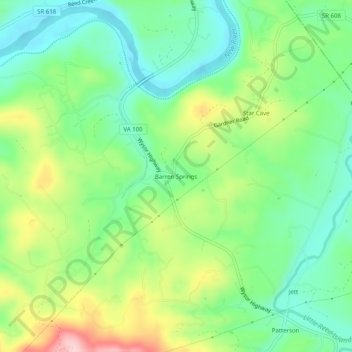
Nome: Mapa topográfico Barren Springs, altitude, relevo.
Local: Barren Springs, Wythe County, Virginia, 24313, United States (36.88818 -80.82063 36.92818 -80.78063)
Altitude média: 642 m
Altitude mínima: 564 m
Altitude máxima: 784 m
Outros mapas topográficos
Clique em um mapa para visualizar sua topografia, sua altitude e seu relevo.
Austinville
United States > Virginia > Wythe County
Austinville, Wythe County, Virginia, 24312, United States
Altitude média: 645 m
Ivanhoe
United States > Virginia > Wythe County
Ivanhoe, Wythe County, Virginia, 24350, United States
Altitude média: 643 m
Cripple Creek
United States > Virginia > Wythe County > Speedwell
Cripple Creek, Speedwell, Wythe County, Virginia, 24374, United States
Altitude média: 733 m
Wytheville
United States > Virginia > Wythe County
Wytheville, Wythe County, Virginia, 24382, United States
Altitude média: 720 m
Max Meadows
United States > Virginia > Wythe County
Max Meadows, Wythe County, Virginia, United States
Altitude média: 662 m
Stones Mill
United States > Virginia > Wythe County > Wytheville > Stones Mill
Stones Mill, Wytheville, Wythe County, Virginia, 24382, United States
Altitude média: 710 m