
Mapa topográfico Arches National Park
Mapa interativo
Clique no mapa para exibir a altitude.
Sobre este mapa
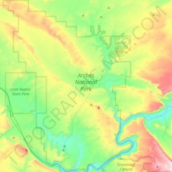
Nome: Mapa topográfico Arches National Park, altitude, relevo.
Local: Arches National Park, Grand County, Utah, United States (38.60474 -109.71320 38.84693 -109.47771)
Altitude média: 1476 m
Altitude mínima: 1206 m
Altitude máxima: 1995 m
The park consists of 310.31 square kilometres (76,680 acres; 119.81 sq mi; 31,031 ha) of high desert located on the Colorado Plateau. The highest elevation in the park is 5,653 feet (1,723 m) at Elephant Butte, and the lowest elevation is 4,085 feet (1,245 m) at the visitor center. The park receives an average of less than 10 inches (250 mm) of rain annually.
Outros mapas topográficos
Clique em um mapa para visualizar sua topografia, sua altitude e seu relevo.
Moab
United States > Utah > Grand County
Moab, Grand County, Utah, 84532, United States
Altitude média: 1357 m
Manns Peak
United States > Utah > Grand County
Manns Peak, Grand County, Utah, United States
Altitude média: 3427 m
Castle Valley
United States > Utah > Grand County
Castle Valley, Grand County, Utah, United States
Altitude média: 1610 m
Castleton Tower
United States > Utah > Grand County
Castleton Tower, Grand County, Utah, United States
Altitude média: 1549 m