
Mapa topográfico Moab
Mapa interativo
Clique no mapa para exibir a altitude.
Sobre este mapa
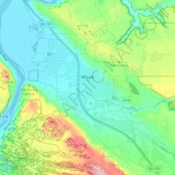
Nome: Mapa topográfico Moab, altitude, relevo.
Local: Moab, Grand County, Utah, 84532, United States (38.53621 -109.57965 38.60318 -109.51532)
Altitude média: 1357 m
Altitude mínima: 1200 m
Altitude máxima: 1746 m
Moab is just south of the Colorado River, at an elevation of 4,025 feet (1,227 m) on the Colorado Plateau. It is 18 miles (29 km) west of the Utah/Colorado state line. Via U.S. Route 191, it is 31 miles (50 km) south of Interstate 70 at Crescent Junction, and it is 54 miles (87 km) north of Monticello. Via Utah State Route 128 it is 46 miles (74 km) southwest of Cisco. The entrance to Arches National Park is 4 miles (6 km) north of Moab on US 191. Hurrah Pass is located on the trail between Moab and Chicken Corners.
Outros mapas topográficos
Clique em um mapa para visualizar sua topografia, sua altitude e seu relevo.
Manns Peak
United States > Utah > Grand County
Manns Peak, Grand County, Utah, United States
Altitude média: 3427 m
Castle Valley
United States > Utah > Grand County
Castle Valley, Grand County, Utah, United States
Altitude média: 1610 m
Castleton Tower
United States > Utah > Grand County
Castleton Tower, Grand County, Utah, United States
Altitude média: 1549 m
Arches National Park
United States > Utah > Grand County
Arches National Park, Grand County, Utah, United States
Altitude média: 1476 m