
Mapa topográfico Churchill County
Mapa interativo
Clique no mapa para exibir a altitude.
Sobre este mapa
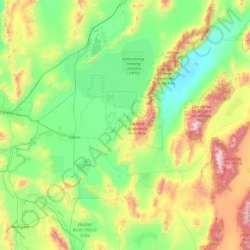
Nome: Mapa topográfico Churchill County, altitude, relevo.
Local: Churchill County, Nevada, United States of America (39.07364 -119.22574 40.00304 -117.46018)
Altitude média: 1476 m
Altitude mínima: 1029 m
Altitude máxima: 3027 m
The terrain of Churchill County consists of rugged mountainous ridges, dotted with lakes and ponds. The county's east and west sides are higher than the intermediate valley; its highest point around the county periphery is a ridge on the lower east boundary line, at 9,380' (2859m) ASL. The county has an area of 5,024 square miles (13,010 km2), of which 4,930 square miles (12,800 km2) is land and 94 square miles (240 km2) (1.9%) is water. The county's highest point is Desatoya Peak at 9,977' (3041m), while the most topographically prominent peak is Mount Augusta, at 9,970' (3039m) ASL.
Outros mapas topográficos
Clique em um mapa para visualizar sua topografia, sua altitude e seu relevo.
Pershing County
United States of America > Nevada
Pershing County, Nevada, United States of America
Altitude média: 1449 m
Esmeralda County
United States of America > Nevada
Esmeralda County, Nevada, United States of America
Altitude média: 1789 m
Washoe County
United States of America > Nevada
Washoe County, Nevada, United States of America
Altitude média: 1528 m
Elko County
United States of America > Nevada
Elko County, Nevada, United States of America
Altitude média: 1838 m
White Pine County
United States of America > Nevada
White Pine County, Nevada, United States of America
Altitude média: 2049 m