
Mapa topográfico Elko County
Mapa interativo
Clique no mapa para exibir a altitude.
Sobre este mapa
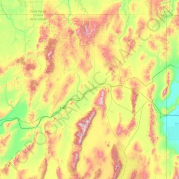
Nome: Mapa topográfico Elko County, altitude, relevo.
Local: Elko County, Nevada, United States of America (40.11784 -117.01775 42.00221 -114.03965)
Altitude média: 1838 m
Altitude mínima: 1283 m
Altitude máxima: 3337 m
According to the U.S. Census Bureau, the county has a total area of 17,203 square miles (44,560 km2), of which 17,170 square miles (44,500 km2) is land and 33 square miles (85 km2) (0.2%) is water. Not counting Alaska's boroughs (four of which are also larger), it is the fourth-largest county in area in the United States (behind San Bernardino County, California, Coconino County, Arizona, and Nye County, Nevada). The elevation ranges from about 4,300 feet (1,300 m) at the edge of the salt flats of the Great Salt Lake Desert, to 11,387 feet (3,471 m) on the summit of Ruby Dome in the Ruby Mountains. The most topographically prominent mountain in Elko County is Pilot Peak.
Outros mapas topográficos
Clique em um mapa para visualizar sua topografia, sua altitude e seu relevo.
Pershing County
United States of America > Nevada
Pershing County, Nevada, United States of America
Altitude média: 1449 m
Esmeralda County
United States of America > Nevada
Esmeralda County, Nevada, United States of America
Altitude média: 1789 m
Washoe County
United States of America > Nevada
Washoe County, Nevada, United States of America
Altitude média: 1528 m
Churchill County
United States of America > Nevada
Churchill County, Nevada, United States of America
Altitude média: 1476 m
White Pine County
United States of America > Nevada
White Pine County, Nevada, United States of America
Altitude média: 2049 m