
Mapa topográfico Appleton-le-Moors
Mapa interativo
Clique no mapa para exibir a altitude.
Sobre este mapa
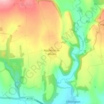
Nome: Mapa topográfico Appleton-le-Moors, altitude, relevo.
Altitude média: 104 m
Altitude mínima: 37 m
Altitude máxima: 196 m
Outros mapas topográficos
Clique em um mapa para visualizar sua topografia, sua altitude e seu relevo.
Fadmoor
United Kingdom > England > North Yorkshire > Ryedale
Fadmoor, Ryedale, North Yorkshire, England, United Kingdom
Altitude média: 148 m
Malton
United Kingdom > England > North Yorkshire > Ryedale > Malton
Malton, Ryedale, North Yorkshire, Yorkshire and the Humber, England, United Kingdom
Altitude média: 28 m
Barton-le-Street
United Kingdom > England > North Yorkshire > Ryedale > Barton-le-Street
Barton-le-Street, Ryedale, North Yorkshire, Yorkshire and the Humber, England, United Kingdom
Altitude média: 43 m