
Mapa topográfico Town of Rushford
Mapa interativo
Clique no mapa para exibir a altitude.
Sobre este mapa
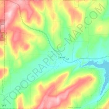
Nome: Mapa topográfico Town of Rushford, altitude, relevo.
Local: Town of Rushford, Allegany County, New York, United States (42.34862 -78.30903 42.43661 -78.19132)
Altitude média: 528 m
Altitude mínima: 430 m
Altitude máxima: 666 m
Outros mapas topográficos
Clique em um mapa para visualizar sua topografia, sua altitude e seu relevo.
Town of Grove
United States > New York > Allegany County
Town of Grove, Allegany County, New York, 14884, United States
Altitude média: 563 m
Town of Birdsall
United States > New York > Allegany County
Town of Birdsall, Allegany County, New York, United States
Altitude média: 581 m
Village of Alfred
United States > New York > Allegany County
Village of Alfred, Town of Alfred, Allegany County, New York, 14802, United States
Altitude média: 597 m
Town of Wellsville
United States > New York > Allegany County
Town of Wellsville, Allegany County, New York, 14895, United States
Altitude média: 564 m
Village of Andover
United States > New York > Allegany County
Village of Andover, Town of Andover, Allegany County, New York, 14806, United States
Altitude média: 561 m
Swain
United States > New York > Allegany County
Swain, Town of Grove, Allegany County, New York, 14884, United States
Altitude média: 503 m
Almond
United States > New York > Allegany County > Almond
Almond, Allegany County, New York, United States
Altitude média: 470 m
Birdsall
United States > New York > Allegany County
Birdsall, Town of Birdsall, Allegany County, New York, United States
Altitude média: 582 m