
Mapa topográfico Village of Alfred
Mapa interativo
Clique no mapa para exibir a altitude.
Sobre este mapa
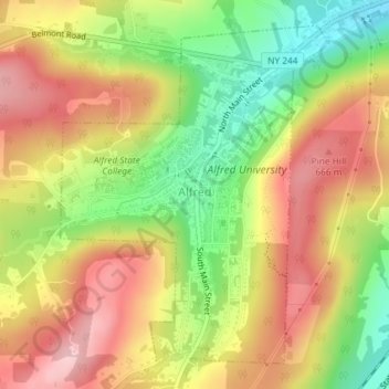
Nome: Mapa topográfico Village of Alfred, altitude, relevo.
Altitude média: 597 m
Altitude mínima: 494 m
Altitude máxima: 686 m
According to the United States Census Bureau, the village has a total area of 1.2 square miles (3.1 km2), all land. A small stream, Kanakadea Creek, flows through the center of the village, then to the Canisteo River, part of the Susquehanna River watershed. The topography is steep hill country, part of the Allegheny Plateau, a physiographic region that is part of the Appalachian Mountains.
Outros mapas topográficos
Clique em um mapa para visualizar sua topografia, sua altitude e seu relevo.
Town of Grove
United States > New York > Allegany County
Town of Grove, Allegany County, New York, 14884, United States
Altitude média: 563 m
Town of Birdsall
United States > New York > Allegany County
Town of Birdsall, Allegany County, New York, United States
Altitude média: 581 m
Town of Wellsville
United States > New York > Allegany County
Town of Wellsville, Allegany County, New York, 14895, United States
Altitude média: 564 m
Village of Andover
United States > New York > Allegany County
Village of Andover, Town of Andover, Allegany County, New York, 14806, United States
Altitude média: 561 m
Town of Rushford
United States > New York > Allegany County
Town of Rushford, Allegany County, New York, United States
Altitude média: 528 m
Swain
United States > New York > Allegany County
Swain, Town of Grove, Allegany County, New York, 14884, United States
Altitude média: 503 m
Almond
United States > New York > Allegany County > Almond
Almond, Allegany County, New York, United States
Altitude média: 470 m
Birdsall
United States > New York > Allegany County
Birdsall, Town of Birdsall, Allegany County, New York, United States
Altitude média: 582 m