
Mapa topográfico Madill
Mapa interativo
Clique no mapa para exibir a altitude.
Sobre este mapa
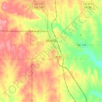
Nome: Mapa topográfico Madill, altitude, relevo.
Local: Madill, Marshall County, Oklahoma, 73446, United States (34.02561 -96.79837 34.13279 -96.72625)
Altitude média: 248 m
Altitude mínima: 198 m
Altitude máxima: 290 m
There is also a small municipal airport (FAA code 1F4) named Madill Municipal Airport, 3 miles (4.8 km) northwest of the city. It has one asphalt runway, 18/36, that is 3,000 feet (910 m) by 60 feet (18 m) at elevation 862 feet (263 m). The airport beacon operates between sunrise and sunset every day. There is no control tower.
Outros mapas topográficos
Clique em um mapa para visualizar sua topografia, sua altitude e seu relevo.
Lake Texoma
United States > Oklahoma > Marshall County
Lake Texoma, Marshall County, Oklahoma, United States
Altitude média: 213 m
Antioch
United States > Oklahoma > Marshall County
Antioch, Marshall County, Oklahoma, United States
Altitude média: 269 m
Kingston
United States > Oklahoma > Marshall County
Kingston, Marshall County, Oklahoma, United States
Altitude média: 239 m
Cumberland
United States > Oklahoma > Marshall County > Cumberland
Cumberland, Marshall County, Oklahoma, United States
Altitude média: 212 m