
Mapa topográfico Lake Texoma
Mapa interativo
Clique no mapa para exibir a altitude.
Sobre este mapa
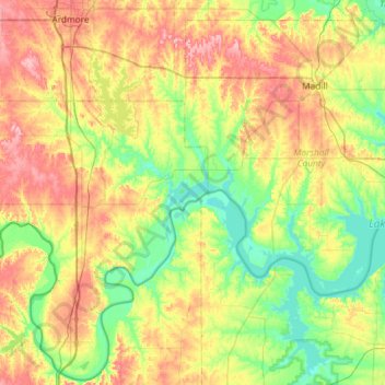
Nome: Mapa topográfico Lake Texoma, altitude, relevo.
Local: Lake Texoma, Marshall County, Oklahoma, United States (33.71228 -97.06889 34.16391 -96.51384)
Altitude média: 213 m
Altitude mínima: 148 m
Altitude máxima: 308 m
Normal elevation of the conservation pool varies from 615 to 619 ft (187 to 189 m) National Geodetic Vertical Datum (NGVD) depending on the time of year. The flood control pool extends to elevation 645 ft (197 m) NGVD. The lake has crested the dam's spillway at a height of 640 ft (200 m) five times: once in 1957, again in 1990, 2007, May 24, 2015, and most recently on June 18, 2015. (USACE 2003a) The lake's previously highest elevation was recorded on May 6, 1990, at 644.76 feet. This record was broken on May 29, 2015, and the lake crested on June 1, 2015, at a new record elevation of 645.72 feet. The top of Denison Dam is at 670 feet.
Outros mapas topográficos
Clique em um mapa para visualizar sua topografia, sua altitude e seu relevo.
Antioch
United States > Oklahoma > Marshall County
Antioch, Marshall County, Oklahoma, United States
Altitude média: 269 m
Kingston
United States > Oklahoma > Marshall County
Kingston, Marshall County, Oklahoma, United States
Altitude média: 239 m
Madill
United States > Oklahoma > Marshall County
Madill, Marshall County, Oklahoma, 73446, United States
Altitude média: 248 m
Cumberland
United States > Oklahoma > Marshall County > Cumberland
Cumberland, Marshall County, Oklahoma, United States
Altitude média: 212 m