
Mapa topográfico Buxton
Mapa interativo
Clique no mapa para exibir a altitude.
Sobre este mapa
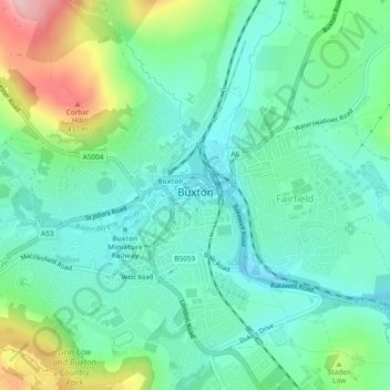
Nome: Mapa topográfico Buxton, altitude, relevo.
Local: Buxton, High Peak, Derbyshire, England, United Kingdom (53.24499 -1.93022 53.27317 -1.88366)
Altitude média: 334 m
Altitude mínima: 285 m
Altitude máxima: 460 m
Buxton has an oceanic climate with short, mild summers and long, cool winters. At about 1,000 feet (300 m) above sea level, Buxton is the highest market town in England. Buxton's elevation makes it cooler and wetter than surrounding towns, with a daytime temperature typically about 2 °C lower than Manchester.
Outros mapas topográficos
Clique em um mapa para visualizar sua topografia, sua altitude e seu relevo.
Chapel-en-le-Frith
United Kingdom > England > Derbyshire > High Peak
Chapel-en-le-Frith, High Peak, Derbyshire, England, United Kingdom
Altitude média: 324 m