
Mapa topográfico Chapel-en-le-Frith
Mapa interativo
Clique no mapa para exibir a altitude.
Sobre este mapa
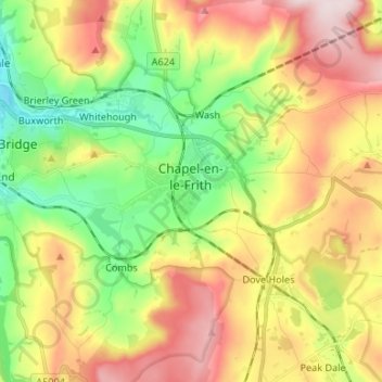
Nome: Mapa topográfico Chapel-en-le-Frith, altitude, relevo.
Altitude média: 324 m
Altitude mínima: 150 m
Altitude máxima: 541 m
Outros mapas topográficos
Clique em um mapa para visualizar sua topografia, sua altitude e seu relevo.
Buxton
United Kingdom > England > Derbyshire > High Peak
Buxton, High Peak, Derbyshire, England, United Kingdom
Altitude média: 334 m