
Mapa topográfico Scottish Borders
Clique no mapa para exibir a altitude.
Sobre este mapa
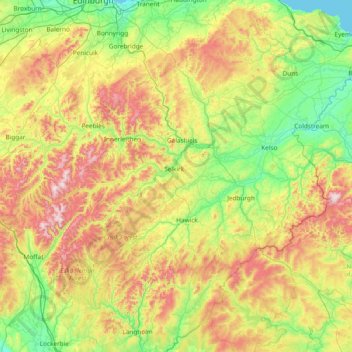
Nome: Mapa topográfico Scottish Borders, altitude, relevo.
Local: Scottish Borders, Scotland, United Kingdom (55.10834 -3.53980 55.94662 -2.03321)
Altitude média: 257 m
Altitude mínima: 0 m
Altitude máxima: 836 m
Outros mapas topográficos
Clique em um mapa para visualizar sua topografia, sua altitude e seu relevo.
Edinburgh
United Kingdom > Scotland > Edinburgh
Some have called Edinburgh the Athens of the North for a variety of reasons. The earliest comparison between the two cities showed that they had a similar topography, with the Castle Rock of Edinburgh performing a similar role to the Athenian Acropolis. Both of them had flatter, fertile agricultural land…
Altitude média: 104 m
Glasgow
United Kingdom > Scotland > Glasgow City
Glasgow itself was reputed to have been founded by the Christian missionary Saint Mungo in the 6th century. He established a church on the Molendinar Burn, where the present Glasgow Cathedral stands, and in the following years Glasgow became a religious centre. Glasgow grew over the following centuries. The…
Altitude média: 128 m
Aberdeen
United Kingdom > Scotland > Aberdeen
Two weather stations collect climate data for the area, Aberdeen/Dyce Airport, and Craibstone. Both are about 4 1⁄2 miles (7 km) to the north west of the city centre, and given that they are in close proximity to each other, exhibit very similar climatic regimes. Dyce tends to have marginally warmer daytime…
Altitude média: 52 m
Ballater
United Kingdom > Scotland > Aberdeenshire
Ballater (/ˈbælətər/, Scottish Gaelic: Bealadair) is a village in Aberdeenshire, Scotland, on the River Dee, immediately east of the Cairngorm Mountains. Situated at an elevation of 213 metres (699 feet), Ballater is a centre for hikers and known for its spring water, once said to cure scrofula. It is home…
Altitude média: 360 m
Dundee
United Kingdom > Scotland > Dundee City
Dundee sits on the north bank of the Firth of Tay on the eastern, North Sea Coast of Scotland. The city lies 36.1 miles (58 km) NNE of Edinburgh and 360.6 miles (580 km) NNW of London. The built-up area occupies a roughly rectangular shape 8.3 miles (13 km) long by 2.5 miles (4 km) wide, aligned in an east to…
Altitude média: 82 m
Kirkcaldy
United Kingdom > Scotland > Fife
Towards the end of the 16th century, a detailed assessment on the size of the townscape was carried out. The first estimate of the parish population in 1639 was between 3,000 and 3,200 and around 3,400 by 1691. At the beginning of the 18th century, the population declined. A census by Webster's Topographical…
Altitude média: 50 m
Ben Nevis
United Kingdom > Scotland > Highland
Ben Nevis has a highland (alpine) maritime (oceanic) polar climate (ET climate in the Köppen classification). Ben Nevis's elevation, maritime location and topography frequently lead to cool and cloudy weather conditions, which can pose a danger to ill-equipped walkers. According to the observations carried…
Altitude média: 912 m
Fort William
United Kingdom > Scotland > Highland
Fort William has an oceanic climate (Cfb) with moderate, but generally cool, temperatures and abundant precipitation. In the towns immediate vicinity, there are significant variations in elevation, which leads to some uninhabited areas near the town having a subpolar oceanic climate (Cfc), or, at the absolute…
Altitude média: 122 m
Glasgow
United Kingdom > Scotland > Glasgow City
Glasgow itself was reputed to have been founded by the Christian missionary Saint Mungo in the 6th century. He established a church on the Molendinar Burn, where the present Glasgow Cathedral stands, and in the following years Glasgow became a religious centre. Glasgow grew over the following centuries as part…
Altitude média: 128 m
Kinlochleven
United Kingdom > Scotland > Highland
Work on the dam and water supply system began in 1905 and was completed in 1907. The hydro-electric scheme was constructed for the British Aluminium Company and was designed by engineer brothers Patrick and Charles Meik. The chief assistant resident engineer on the project was a young William Halcrow. The…
Altitude média: 306 m
Ben Klibreck
United Kingdom > Scotland > Highland
Ben Klibreck (Scottish Gaelic: Beinn Chlìbric) is a Scottish mountain located in central Sutherland. It is an isolated mountain, rising above a large area of moorland. The highest point, Meall nan Con (the mound of the dogs), rises to 962 metres (3,156 ft) elevation and is therefore the second most northerly…
Altitude média: 551 m
Canisp
United Kingdom > Scotland > Highland
Canisp is an isolated mountain that stands in the Glencanisp Forest, a large rock and water wilderness. It has a topographic prominence of 691 metres (2,267 ft). Canisp has little vegetation, even on its lower slopes large areas of Gneiss (one of the oldest rocks in the world) are visible on the surface.
Altitude média: 467 m
Fort Augustus
United Kingdom > Scotland > Highland
As with most of the British Isles and Scotland, Fort Augustus has an oceanic climate (Köppen: Cfb) with cool summers and mild winters. Like a lot of the surrounding area, sunshine levels are low at around 1,005 hours per annum and temperatures are unpredictable – Fort Augustus holds the UK's joint lowest…
Altitude média: 115 m
Ailsa Craig
In a small glen above Ailsa Castle, a small freshwater body known as the Garry Loch is located at an altitude of 247 m (810 ft), with a depth of at least 17 feet.
Altitude média: 14 m
Mull of Kintyre
Ailsa Craig and the County Antrim coast of Ulster and Rathlin Island are all clearly visible from the Mull. On clearer days it is also possible to make out Malin Head in Inishowen in County Donegal in the west of Ulster, and the Ayrshire coast on the other side of Ailsa Craig. Other islands in the Firth of…
Altitude média: 84 m
Aberlour
United Kingdom > Scotland > Moray
According to the 1846 A Topographical Dictionary of Scotland, "This parish, formerly called Skirdustan, signifying, in the Gaelic tongue, 'the division of Dustan', its tutelary saint, derived its present name from its situation at the mouth of a noisy burn, which discharges itself into the river Spey."
Altitude média: 160 m
Coatbridge
United Kingdom > Scotland > North Lanarkshire
The topography of Coatbridge was an important feature in the town's development during the industrial revolution. Coatbridge rests 60 metres below the "Slamannan plateau" and neighbouring Airdrie sits on its edge. The low-lying flat ground of Coatbridge was a vital factor in the siting of the town's blast…
Altitude média: 100 m
Airdrie
United Kingdom > Scotland > North Lanarkshire
Airdrie's name first appeared in the Register of the Great Seal of Scotland (Registrum Magni Sigilii Regum Scotorum) in 1373 as Ardre. By 1546 it had become Ardry and by 1587 it was known as Ardrie. In 1630 it finally appeared in the Register as Airdrie. Given the topography of the area, the most likely…
Altitude média: 135 m
Ben Vorlich
United Kingdom > Scotland > Perth and Kinross
Due to its prominence when seen from the lower ground of the Central Belt, Ben Vorlich is one of the most commonly seen of Munros, Scotland's peaks of at least 3,000 ft (914.4 m) elevation. It lies in an area of land bounded to the north by Loch Earn and to the west by Loch Lubnaig. The town of Callander lies…
Altitude média: 646 m