
Faça uma doação
Prepare-se para a sua próxima aventura:
Como Associado da Amazon, este site recebe uma comissão sobre compras elegíveis sem custo adicional para si.
Mapa topográfico Marvdasht
Clique no mapa para exibir a altitude.
Faça uma doação
Prepare-se para a sua próxima aventura:
Como Associado da Amazon, este site recebe uma comissão sobre compras elegíveis sem custo adicional para si.
Marvdasht
Marvdasht is one of the northern cities and also counties of Fars province. The city is located 45 km north of Shiraz and has an altitude of 1620 meters above the sea level. The county has an area of 3687 square kilometers and neighbors Arsenjan in the east, Pasargad in the north, Khorambid and Eghlid in the northwest, Sepidan in the southwest and Shiraz in the south.
Faça uma doação
Prepare-se para a sua próxima aventura:
Como Associado da Amazon, este site recebe uma comissão sobre compras elegíveis sem custo adicional para si.
Sobre este mapa
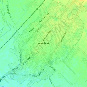
Nome: Mapa topográfico Marvdasht, altitude, relevo.
Altitude média: 1598 m
Altitude mínima: 1589 m
Altitude máxima: 1608 m
Faça uma doação
Prepare-se para a sua próxima aventura:
Como Associado da Amazon, este site recebe uma comissão sobre compras elegíveis sem custo adicional para si.
Outros mapas topográficos
Clique em um mapa para visualizar sua topografia, sua altitude e seu relevo.
Doroodzan Dam
Iran > Fars Province > Marvdasht County > دهستان درودزن > Dorudzan
Altitude média: 1706 m
Marvdasht
Iran > Fars Province > Marvdasht County > شهر مرودشت
Marvdasht is one of the northern cities and also counties of Fars province. The city is located 45 km north of Shiraz and has an altitude of 1620 meters above the sea level. The county has an area of 3687 square kilometers and neighbors Arsenjan in the east, Pasargad in the north, Khorambid and Eghlid in the…
Altitude média: 1598 m
Faça uma doação
Prepare-se para a sua próxima aventura:
Como Associado da Amazon, este site recebe uma comissão sobre compras elegíveis sem custo adicional para si.