
Faça uma doação
Prepare-se para a sua próxima aventura:
Como Associado da Amazon, este site recebe uma comissão sobre compras elegíveis sem custo adicional para si.
Mapa topográfico Marvdasht
Clique no mapa para exibir a altitude.
Faça uma doação
Prepare-se para a sua próxima aventura:
Como Associado da Amazon, este site recebe uma comissão sobre compras elegíveis sem custo adicional para si.
Marvdasht
Marvdasht is one of the northern cities and also counties of Fars province. The city is located 45 km north of Shiraz and has an altitude of 1620 meters above the sea level. The county has an area of 3687 square kilometers and neighbors Arsenjan in the east, Pasargad in the north, Khorambid and Eghlid in the northwest, Sepidan in the southwest and Shiraz in the south. There are three cities in the county: Marvdasht, Seydan and Kamfirouz. Marvdasht as a county is divided into four districts: Central, Kamfirouz, Doroudzan and Seydan. Marvdasht has a cold weather in the hilly areas and moderate climate in other regions.
Faça uma doação
Prepare-se para a sua próxima aventura:
Como Associado da Amazon, este site recebe uma comissão sobre compras elegíveis sem custo adicional para si.
Sobre este mapa
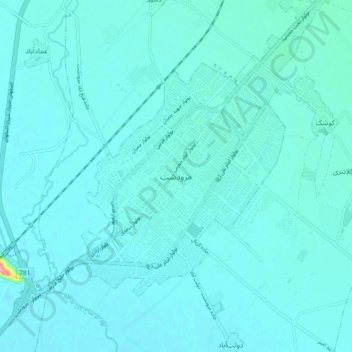
Nome: Mapa topográfico Marvdasht, altitude, relevo.
Altitude média: 1598 m
Altitude mínima: 1587 m
Altitude máxima: 1723 m
Faça uma doação
Prepare-se para a sua próxima aventura:
Como Associado da Amazon, este site recebe uma comissão sobre compras elegíveis sem custo adicional para si.