
Mapa topográfico Grantham
Clique no mapa para exibir a altitude.
Sobre este mapa
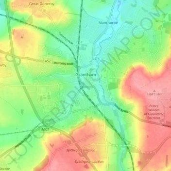
Nome: Mapa topográfico Grantham, altitude, relevo.
Altitude média: 84 m
Altitude mínima: 43 m
Altitude máxima: 135 m
Outros mapas topográficos
Clique em um mapa para visualizar sua topografia, sua altitude e seu relevo.
Moor Barn
United Kingdom > England > Lincolnshire > South Kesteven > Hough-on-the-Hill
Altitude média: 31 m
Witham on the Hill
United Kingdom > England > Lincolnshire > South Kesteven > Witham on the Hill
Altitude média: 43 m
Old Somerby
United Kingdom > England > Lincolnshire > South Kesteven > Old Somerby
Altitude média: 115 m
Sempringham
United Kingdom > England > Lincolnshire > South Kesteven > Pointon
Sempringham consists of a church and a holy well, with other houses east from the church scattered along the B1177 between Pointon and Billingborough. The church stands at an altitude of about 52 feet (16 m), on land rising out of flat fenland. Pointon is the chief township of the civil parish, which includes…
Altitude média: 16 m
Uffington Park
United Kingdom > England > Lincolnshire > South Kesteven > Uffington
Altitude média: 30 m
Little Haw Wood
United Kingdom > England > Lincolnshire > South Kesteven > Castle Bytham
Altitude média: 92 m
Grimsthorpe
United Kingdom > England > Lincolnshire > South Kesteven > Grimsthorpe
Altitude média: 55 m