Geolocalizar

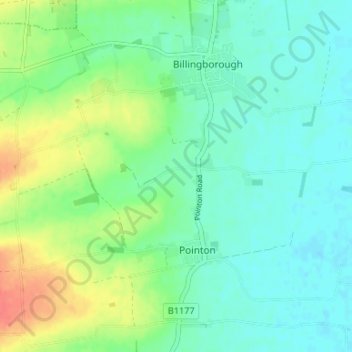
Mapa topográfico Sempringham

Clique no mapa para exibir a altitude.

Sempringham

Sempringham consists of a church and a holy well, with other houses east from the church scattered along the B1177 between Pointon and Billingborough. The church stands at an altitude of about 52 feet (16 m), on land rising out of flat fenland. Pointon is the chief township of the civil parish, which includes Millthorpe and the fens of Pointon, Neslam and Aslackby, and a part of Hundred Fen at Gosberton Clough. Formerly, Birthorpe, now part of Billingborough, was included in the parish.

Wikipedia (CC-BY-SA 3.0)

Sobre este mapa

Nome: Mapa topográfico Sempringham, altitude, relevo.

Local: Sempringham, Pointon and Sempringham, Pointon, South Kesteven, Lincolnshire, England, NG34 0LY, United Kingdom (52.86112 -0.36704 52.90112 -0.32704)

Altitude média: 16 m

Altitude mínima: 1 m

Altitude máxima: 50 m

Prepare-se para a sua próxima aventura:

🚶Acessórios para Caminhadas - Conforto e segurança
👟Sapatos de Trekking - Calçado leve e aderente para caminhadas longas
📏Altímetros Portáteis - Medição precisa de altitude
🧼Sabão Biodegradável para Campismo - Higiene pessoal que respeita o meio ambiente aquático
🔋Pilhas Recarregáveis para GPS - Energia sustentável para dispositivos eletrónicos de campo

Como Associado da Amazon, este site recebe uma comissão sobre compras elegíveis sem custo adicional para si.