
Mapa topográfico Den Dolder
Mapa interativo
Clique no mapa para exibir a altitude.
Sobre este mapa
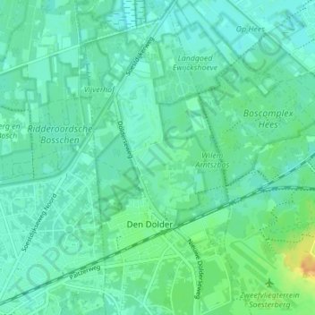
Nome: Mapa topográfico Den Dolder, altitude, relevo.
Local: Den Dolder, Zeist, Utrecht, Nederland (52.12913 5.22500 52.17125 5.25684)
Altitude média: 7 m
Altitude mínima: 0 m
Altitude máxima: 28 m
Outros mapas topográficos
Clique em um mapa para visualizar sua topografia, sua altitude e seu relevo.
Huis ter Heide
Huis ter Heide, Zeist, Utrecht, Nederland
Altitude média: 12 m
Slot Zeist
Slot Zeist, slotplein, Zeist, Utrecht, Nederland, 3703DX, Nederland
Altitude média: 6 m