
Mapa topográfico Austerlitz
Mapa interativo
Clique no mapa para exibir a altitude.
Sobre este mapa
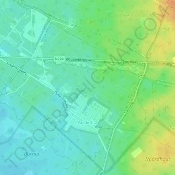
Nome: Mapa topográfico Austerlitz, altitude, relevo.
Local: Austerlitz, Zeist, Utrecht, Nederland (52.07033 5.29088 52.09645 5.33262)
Altitude média: 20 m
Altitude mínima: 8 m
Altitude máxima: 43 m
Outros mapas topográficos
Clique em um mapa para visualizar sua topografia, sua altitude e seu relevo.
Huis ter Heide
Huis ter Heide, Zeist, Utrecht, Nederland
Altitude média: 12 m
Slot Zeist
Slot Zeist, slotplein, Zeist, Utrecht, Nederland, 3703DX, Nederland
Altitude média: 6 m