
Mapa topográfico Spencer
Mapa interativo
Clique no mapa para exibir a altitude.
Sobre este mapa
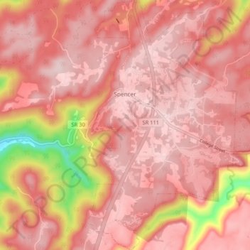
Nome: Mapa topográfico Spencer, altitude, relevo.
Altitude média: 496 m
Altitude mínima: 277 m
Altitude máxima: 564 m
Spencer is topographically isolated by the Cumberland Plateau's escarpment to the north and west, the Cane Creek Valley to the east, and the Dry Fork Gulf to the south. Cane Creek, along with its tributary, Dry Fork, slices a narrow valley as it spills down northward toward its confluence with the Caney Fork, effectively dividing the Spencer area from the rest of the plateau. Cane Creek's upper watershed, known for its scenic waterfalls and geological formations, comprises the bulk of Fall Creek Falls State Park.
Outros mapas topográficos
Clique em um mapa para visualizar sua topografia, sua altitude e seu relevo.
Fall Creek Falls State Park
United States > Tennessee > Van Buren County
Fall Creek Falls State Park, Van Buren County, Tennessee, United States
Altitude média: 524 m
Welchland
United States > Tennessee > Van Buren County
Welchland, Van Buren County, Tennessee, United States
Altitude média: 542 m