
Mapa topográfico Fall Creek Falls State Park
Mapa interativo
Clique no mapa para exibir a altitude.
Sobre este mapa
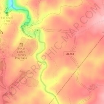
Nome: Mapa topográfico Fall Creek Falls State Park, altitude, relevo.
Altitude média: 524 m
Altitude mínima: 413 m
Altitude máxima: 564 m
Just beyond its source, Cane Creek slowly gains strength as it absorbs Meadow Creek and several smaller streams. As the creek enters the gorge, it drops several hundred feet in less than a mile, including 45 feet (14 m) over Cane Creek Cascades and 85 feet (26 m) over Cane Creek Falls. A few hundred meters north of Cane Creek Falls, Rockhouse Creek spills 125 feet (38 m) over a plunge waterfall. Over the next half-mile, Cane Creek absorbs Fall Creek and Piney Creek, both of which enter from smaller gorges to the immediate west. During this stretch, part of the creek disappears underground into limestone sinks and reemerges at a spring known as "Crusher Hole." Cane Creek continues to lose elevation before steadying near its confluence with Dry Fork. Beyond Dry Fork, the creek gradually descends to the Highland Rim, where it empties into the Caney Fork River.
Outros mapas topográficos
Clique em um mapa para visualizar sua topografia, sua altitude e seu relevo.
Spencer
United States > Tennessee > Van Buren County
Spencer, Van Buren County, Middle Tennessee, Tennessee, 38585, United States
Altitude média: 496 m
Welchland
United States > Tennessee > Van Buren County
Welchland, Van Buren County, Tennessee, United States
Altitude média: 542 m