Geolocalizar

Mapa topográfico Ben More

Clique no mapa para exibir a altitude.

Ben More

Ben More (Scottish Gaelic: Beinn Mhòr, meaning "great mountain") is the highest mountain and only Munro (mountains in Scotland that reach an elevation of at least 3,000 feet or 914.4 metres) on the Isle of Mull, Scotland. It is also the highest peak in the Scottish isles – and the only Munro – apart from those on the Isle of Skye. The mountain is situated close to the centre of the island, above the shores of Loch na Keal.

Wikipedia (CC-BY-SA 3.0)

Sobre este mapa

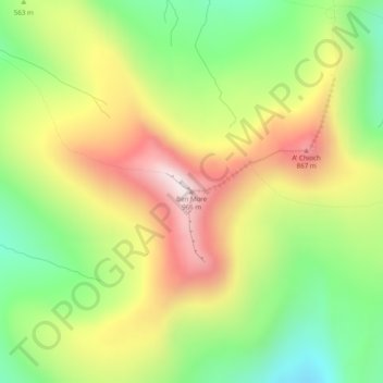
Nome: Mapa topográfico Ben More, altitude, relevo.

Local: Ben More, Argyll and Bute, Scotland, PA70 6HQ, United Kingdom (56.42478 -6.01409 56.42488 -6.01399)

Altitude média: 574 m

Altitude mínima: 243 m

Altitude máxima: 962 m

Outros mapas topográficos

Clique em um mapa para visualizar sua topografia, sua altitude e seu relevo.

Gigha

United Kingdom > Scotland > Argyll and Bute > Ardminish

Gigha lies 5 kilometres (3 mi) off the coast of Kintyre and is 9.5 km (6 mi) long in a roughly north-south direction and a maximum of 2.5 km (1 1⁄2 mi) wide. The total area is 1,395 hectares (3,450 acres) and the highest elevation of Creag Bhàn reaches only 100 m (330 ft). The rocky central spine is…

Altitude média: 3 m

Loch Awe

United Kingdom > Scotland > Argyll and Bute > Lochawe

Altitude média: 218 m

Islay

United Kingdom > Scotland > Argyll and Bute

Altitude média: 53 m

Bute

United Kingdom > Scotland > Argyll and Bute > Ardbeg

Altitude média: 41 m

Mull

United Kingdom > Scotland > Argyll and Bute

Altitude média: 122 m

Cara

United Kingdom > Scotland > Argyll and Bute

Altitude média: 1 m

Bowmore

United Kingdom > Scotland > Argyll and Bute

Altitude média: 13 m

Lismore

United Kingdom > Scotland > Argyll and Bute > Achnacroish

The island of Lismore lies in Loch Linnhe, north east of Mull, in the Argyll and Bute council area. It is 15 kilometres (9.3 mi) long and about 2 kilometres (1.2 mi) wide and oriented from SW to NE, roughly parallel to the Great Glen Fault. To the east is an arm of Loch Linnhe known as the Lynn of Lorn.…

Altitude média: 16 m

Kilmartin

United Kingdom > Scotland > Argyll and Bute

Altitude média: 112 m

Tarbert

United Kingdom > Scotland > Argyll and Bute

Altitude média: 69 m

Loch Ba

United Kingdom > Scotland > Argyll and Bute

Altitude média: 141 m

Bowmore

United Kingdom > Scotland > Argyll and Bute

Altitude média: 13 m

Staffa

United Kingdom > Scotland > Argyll and Bute

Altitude média: 0 m

Kerrera

United Kingdom > Scotland > Argyll and Bute > Oban

Altitude média: 34 m

Torsa

United Kingdom > Scotland > Argyll and Bute > Ardinamir

Altitude média: 12 m

Staffa

United Kingdom > Scotland > Argyll and Bute

Altitude média: 0 m

Islay

United Kingdom > Scotland > Argyll and Bute

Altitude média: 53 m

Staffa

United Kingdom > Scotland > Argyll and Bute

Altitude média: 0 m

Loch Sloy

United Kingdom > Scotland > Argyll and Bute

Altitude média: 479 m

Islay

United Kingdom > Scotland > Argyll and Bute

Altitude média: 53 m

Bute

United Kingdom > Scotland > Argyll and Bute > Ardbeg

Altitude média: 41 m

Staffa

United Kingdom > Scotland > Argyll and Bute

Altitude média: 0 m

Bowmore

United Kingdom > Scotland > Argyll and Bute

Altitude média: 13 m

Texa

United Kingdom > Scotland > Argyll and Bute

Altitude média: 1 m

Kilmartin

United Kingdom > Scotland > Argyll and Bute

Altitude média: 112 m

Prepare-se para a sua próxima aventura:

📸Tripés de Viagem Leves - Suportes estáveis para fotografia de paisagem e longa exposição
🕶️Clips Solares para Óculos - Transforma óculos graduados em óculos de sol para outdoor
🧭Bússolas Digitais - Orientação moderna
🕶️Óculos de Sol Desportivos - Proteção UV para atividades outdoor
💊Pastilhas de Purificação de Água - Solução química rápida para tornar a água segura para consumo

Como Associado da Amazon, este site recebe uma comissão sobre compras elegíveis sem custo adicional para si.