Geolocalizar

Mapa topográfico Mull

Clique no mapa para exibir a altitude.

Sobre este mapa

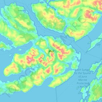
Nome: Mapa topográfico Mull, altitude, relevo.

Local: Mull, Argyll and Bute, Scotland, United Kingdom (56.26284 -6.38584 56.65635 -5.64567)

Altitude média: 122 m

Altitude mínima: -2 m

Altitude máxima: 960 m

Outros mapas topográficos

Clique em um mapa para visualizar sua topografia, sua altitude e seu relevo.

Ben More

United Kingdom > Scotland > Argyll and Bute

Ben More (Scottish Gaelic: Beinn Mhòr, meaning "great mountain") is the highest mountain and only Munro (mountains in Scotland that reach an elevation of at least 3,000 feet or 914.4 metres) on the Isle of Mull, Scotland. It is also the highest peak in the Scottish isles – and the only Munro – apart from…

Altitude média: 574 m

Oban

United Kingdom > Scotland > Argyll and Bute

Altitude média: 52 m

Dunoon

United Kingdom > Scotland > Argyll and Bute

Altitude média: 98 m

Peaton

United Kingdom > Scotland > Argyll and Bute

Altitude média: 66 m

Muasdale

United Kingdom > Scotland > Argyll and Bute

Altitude média: 62 m

Bunessan

United Kingdom > Scotland > Argyll and Bute

Altitude média: 32 m

Minard

United Kingdom > Scotland > Argyll and Bute

Altitude média: 73 m

Sandbank

United Kingdom > Scotland > Argyll and Bute

Altitude média: 100 m

Salen

United Kingdom > Scotland > Argyll and Bute

Altitude média: 54 m

Cara

United Kingdom > Scotland > Argyll and Bute

Altitude média: 1 m

Crinan

United Kingdom > Scotland > Argyll and Bute

Altitude média: 41 m

Rhu

United Kingdom > Scotland > Argyll and Bute

Altitude média: 67 m

The Slate

United Kingdom > Scotland > Argyll and Bute

Altitude média: 242 m

Succoth

United Kingdom > Scotland > Argyll and Bute

Altitude média: 235 m

Ormsary

United Kingdom > Scotland > Argyll and Bute

Altitude média: 70 m

Strachur

United Kingdom > Scotland > Argyll and Bute

The area around Strachur borders the Loch Lomond and the Trossachs National Park. The parish is bounded along its north-west side by Loch Fyne - Strachur forming its north-western district, and Strathlachlan its south-western one; and it is bounded on other sides by the parishes of Lochgoilhead, Kilmun,…

Altitude média: 125 m

Kames

United Kingdom > Scotland > Argyll and Bute

Altitude média: 56 m

Lochbuie

United Kingdom > Scotland > Argyll and Bute

Altitude média: 119 m

Saddell

United Kingdom > Scotland > Argyll and Bute

Altitude média: 89 m

Ascog

United Kingdom > Scotland > Argyll and Bute

Altitude média: 22 m

Clachan

United Kingdom > Scotland > Argyll and Bute

Altitude média: 75 m

Strone

United Kingdom > Scotland > Argyll and Bute

Altitude média: 58 m

Glenfyne

United Kingdom > Scotland > Argyll and Bute

Altitude média: 328 m

Leanach

United Kingdom > Scotland > Argyll and Bute

Altitude média: 131 m

Ardfin

United Kingdom > Scotland > Argyll and Bute

Altitude média: 57 m

Ford

United Kingdom > Scotland > Argyll and Bute

Altitude média: 125 m

Bowmore

United Kingdom > Scotland > Argyll and Bute

Altitude média: 13 m

Taynuilt

United Kingdom > Scotland > Argyll and Bute

Altitude média: 49 m

Fearnoch

United Kingdom > Scotland > Argyll and Bute

Altitude média: 67 m

Dalmally

United Kingdom > Scotland > Argyll and Bute

Altitude média: 142 m

Lochawe

United Kingdom > Scotland > Argyll and Bute

Altitude média: 198 m

Rothesay

United Kingdom > Scotland > Argyll and Bute

Altitude média: 38 m

Kilmartin

United Kingdom > Scotland > Argyll and Bute

Altitude média: 112 m

Dunadd

United Kingdom > Scotland > Argyll and Bute

Altitude média: 20 m

Appin

United Kingdom > Scotland > Argyll and Bute

Altitude média: 93 m

Connel

United Kingdom > Scotland > Argyll and Bute

Altitude média: 23 m

Dalavich

United Kingdom > Scotland > Argyll and Bute

Altitude média: 93 m

Coulport

United Kingdom > Scotland > Argyll and Bute

Altitude média: 61 m

Crossaig

United Kingdom > Scotland > Argyll and Bute

Altitude média: 72 m

Obrigado por apoiar este site ❤️
Faça uma doação

Prepare-se para a sua próxima aventura:

Como Associado da Amazon, este site recebe uma comissão sobre compras elegíveis sem custo adicional para si.

Prepare-se para a sua próxima aventura:

📚Guias de Caminhadas em Portugal - Descobrir trilhos portugueses
🏞️Equipamento de Aventura - Essenciais para exploração
🦟Repelentes de Insetos - Proteção contra mosquitos
🌊Equipamento de Praia Selvagem - Aventura costeira e trilhos
🧊Geleiras Portáteis Flexíveis - Transporte de alimentos frescos em saídas de campo diárias

Como Associado da Amazon, este site recebe uma comissão sobre compras elegíveis sem custo adicional para si.