
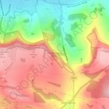
Mapa topográfico Leckhampton Hill
Mapa interativo
Clique no mapa para exibir a altitude.
Sobre este mapa
Nome: Mapa topográfico Leckhampton Hill, altitude, relevo.
Altitude média: 210 m
Altitude mínima: 94 m
Altitude máxima: 298 m
Outros mapas topográficos
Clique em um mapa para visualizar sua topografia, sua altitude e seu relevo.
Charlton Kings
United Kingdom > England > Gloucestershire > Cheltenham
Charlton Kings, Cheltenham, Gloucestershire, England, GL53 8BB, United Kingdom
Altitude média: 125 m
Beeches
United Kingdom > England > Gloucestershire > Cheltenham > Charlton Kings
Beeches, Charlton Kings, Cheltenham, Gloucestershire, England, United Kingdom, Timbercombe
Altitude média: 159 m
Charlton Kings
United Kingdom > England > Gloucestershire > Cheltenham > Charlton Kings
Charlton Kings, Cheltenham, Gloucestershire, England, United Kingdom
Altitude média: 158 m
Prestbury
United Kingdom > England > Gloucestershire > Cheltenham
Prestbury, Cheltenham, Gloucestershire, England, United Kingdom
Altitude média: 63 m
Leckhampton
United Kingdom > England > Gloucestershire > Cheltenham
Leckhampton, Cheltenham, Gloucestershire, England, GL53 0PF, United Kingdom
Altitude média: 118 m
Sudeley Castle
United Kingdom > England > Gloucestershire > Cheltenham > Sudeley
Sudeley Castle, Rushley Lane, Sudeley, Cheltenham, Gloucestershire, England, GL54 5JD, United Kingdom
Altitude média: 135 m
Swindon Village
United Kingdom > England > Gloucestershire > Cheltenham
Swindon Village, Cheltenham, Gloucestershire, England, GL51 9RF, United Kingdom
Altitude média: 43 m