
Mapa topográfico Mount Adams
Mapa interativo
Clique no mapa para exibir a altitude.
Sobre este mapa
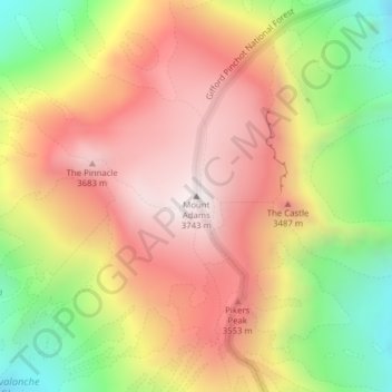
Nome: Mapa topográfico Mount Adams, altitude, relevo.
Local: Mount Adams, Yakima County, Washington, VS (46.20235 -121.49101 46.20245 -121.49091)
Altitude média: 3235 m
Altitude mínima: 2608 m
Altitude máxima: 3741 m
Outros mapas topográficos
Clique em um mapa para visualizar sua topografia, sua altitude e seu relevo.
Maple Valley
VS > Washington > Maple Valley
Maple Valley, King County, Washington, 98038, VS
Altitude média: 160 m
North Cascades National Park
VS > Washington
North Cascades National Park, Whatcom County, Washington, VS
Altitude média: 1151 m
Bellingham
VS > Washington > Bellingham
Bellingham, Whatcom County, Washington, VS
Altitude média: 89 m