
Mapa topográfico Mount Baker
Mapa interativo
Clique no mapa para exibir a altitude.
Sobre este mapa
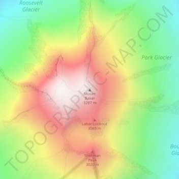
Nome: Mapa topográfico Mount Baker, altitude, relevo.
Local: Mount Baker, Whatcom County, Washington, VS (48.77675 -121.81452 48.77685 -121.81442)
Altitude média: 2696 m
Altitude mínima: 2182 m
Altitude máxima: 3274 m
Outros mapas topográficos
Clique em um mapa para visualizar sua topografia, sua altitude e seu relevo.
Maple Valley
VS > Washington > Maple Valley
Maple Valley, King County, Washington, 98038, VS
Altitude média: 160 m
North Cascades National Park
VS > Washington
North Cascades National Park, Whatcom County, Washington, VS
Altitude média: 1151 m
Bellingham
VS > Washington > Bellingham
Bellingham, Whatcom County, Washington, VS
Altitude média: 89 m