
Mapa topográfico Beyne-Heusay
Mapa interativo
Clique no mapa para exibir a altitude.
Sobre este mapa
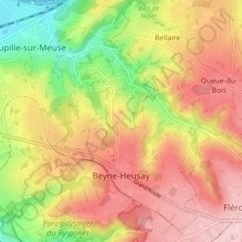
Nome: Mapa topográfico Beyne-Heusay, altitude, relevo.
Local: Beyne-Heusay, Luik, Wallonië, 4610, België (50.61112 5.63549 50.65086 5.69361)
Altitude média: 175 m
Altitude mínima: 56 m
Altitude máxima: 268 m
Beyne-Heusay ligt in het Land van Herve op een hoogte van ongeveer 200 meter. De omgeving is sterk verstedelijkt, wat een gevolg is van de steenkoolwinning en de nabijheid van de Luikse agglomeratie. Enkele landgoedbossen, zoals Bois de Beyne, zijn echter nog aanwezig.
Outros mapas topográficos
Clique em um mapa para visualizar sua topografia, sua altitude e seu relevo.
Villers-Saint-Siméon
België > Luik > Luik > Villers-Saint-Siméon
Villers-Saint-Siméon, Luik, Wallonië, 4453, België
Altitude média: 152 m
Grâce-Hollogne
België > Luik > Luik > Grâce-Hollogne
Grâce-Hollogne, Luik, Wallonië, 4460, België
Altitude média: 143 m
Remouchamps
België > Luik > Luik > Aywaille
Remouchamps, Aywaille, Luik, Wallonië, 4920, België
Altitude média: 222 m
Embourg
België > Luik > Luik > Chaudfontaine
Embourg, Chaudfontaine, Luik, Wallonië, 4050, België
Altitude média: 139 m
Rotheux-Rimière
België > Luik > Luik > Rotheux-Rimière
Rotheux-Rimière, Neupré, Luik, Wallonië, 4120, België
Altitude média: 233 m