
Mapa topográfico Herstal
Mapa interativo
Clique no mapa para exibir a altitude.
Sobre este mapa
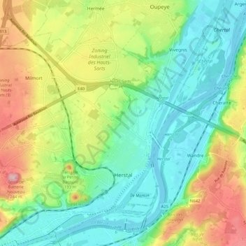
Nome: Mapa topográfico Herstal, altitude, relevo.
Local: Herstal, Luik, Wallonië, 4040, België (50.65470 5.55531 50.70246 5.65705)
Altitude média: 113 m
Altitude mínima: 53 m
Altitude máxima: 219 m
De stad ligt in het laagterras van de Maas, op een hoogte van ongeveer 70 meter. Naar het westen toe neemt de hoogte toe tot 145 meter, en is men in Haspengouw. In het noorden wordt Herstal begrensd door de autoweg A3. De Spoorlijn 34 doorsnijdt Herstal.
Outros mapas topográficos
Clique em um mapa para visualizar sua topografia, sua altitude e seu relevo.
Villers-Saint-Siméon
België > Luik > Luik > Villers-Saint-Siméon
Villers-Saint-Siméon, Luik, Wallonië, 4453, België
Altitude média: 152 m
Grâce-Hollogne
België > Luik > Luik > Grâce-Hollogne
Grâce-Hollogne, Luik, Wallonië, 4460, België
Altitude média: 143 m
Remouchamps
België > Luik > Luik > Aywaille
Remouchamps, Aywaille, Luik, Wallonië, 4920, België
Altitude média: 222 m
Embourg
België > Luik > Luik > Chaudfontaine
Embourg, Chaudfontaine, Luik, Wallonië, 4050, België
Altitude média: 139 m
Rotheux-Rimière
België > Luik > Luik > Rotheux-Rimière
Rotheux-Rimière, Neupré, Luik, Wallonië, 4120, België
Altitude média: 233 m