
Mapa topográfico Val Thorens
Mapa interativo
Clique no mapa para exibir a altitude.
Val Thorens
Val Thorens ([val tɔʁɑ̃]) is a ski town in the Tarentaise Valley in the French Alps at an altitude of 2,300 m (7,500 ft). It is located in the commune of Saint-Martin-de-Belleville in the Savoie department. The resort forms part of the Les Trois Vallées ski area which, with over 600 km of slopes, is one of the largest linked ski areas in the world.
Sobre este mapa
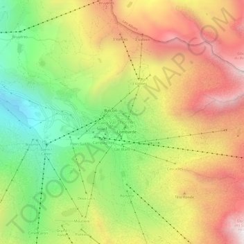
Nome: Mapa topográfico Val Thorens, altitude, relevo.
Altitude média: 2516 m
Altitude mínima: 1914 m
Altitude máxima: 3145 m
Outros mapas topográficos
Clique em um mapa para visualizar sua topografia, sua altitude e seu relevo.
Albertville
France > Auvergne-Rhône-Alpes > Savoy
Albertville is situated on the river Arly, close to the confluence with the river Isère. Its altitude ranges from 345 to 2,037 metres (1,132 to 6,683 ft). Nearby mountains include: Belle Étoile, Dent de Cons, Négresse, Roche Pourrie, Mirantin, Pointe de la Grande Journée, Chaîne du Grand Arc. Nearby…
Altitude média: 595 m