
Mapa topográfico Albertville
Mapa interativo
Clique no mapa para exibir a altitude.
Sobre este mapa
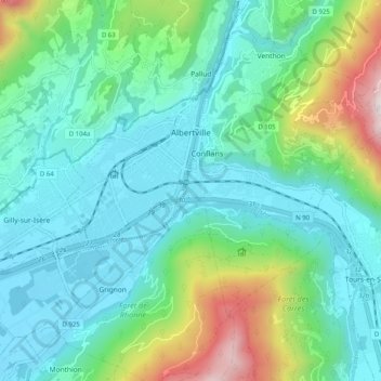
Nome: Mapa topográfico Albertville, altitude, relevo.
Altitude média: 595 m
Altitude mínima: 313 m
Altitude máxima: 1557 m
Albertville is situated on the river Arly, close to the confluence with the river Isère. Its altitude ranges from 345 to 2,037 metres (1,132 to 6,683 ft). Nearby mountains include: Belle Étoile, Dent de Cons, Négresse, Roche Pourrie, Mirantin, Pointe de la Grande Journée, Chaîne du Grand Arc. Nearby mountain ranges include the Bauges, the Beaufortain and the beginning of the Vanoise.
Outros mapas topográficos
Clique em um mapa para visualizar sua topografia, sua altitude e seu relevo.
Val Thorens
France > Auvergne-Rhône-Alpes > Savoy
Val Thorens, Les Belleville, Albertville, Savoy, Auvergne-Rhône-Alpes, Metropolitan France, 73440, France
Altitude média: 2516 m
Villarabout
France > Auvergne-Rhône-Alpes > Savoy > Les Belleville
Villarabout, Saint-Martin-de-Belleville, Les Belleville, Albertville, Savoy, Auvergne-Rhône-Alpes, Metropolitan France, 73440, France
Altitude média: 1600 m
Beaufort
France > Auvergne-Rhône-Alpes > Savoy > Beaufort
Beaufort, Albertville, Savoy, Auvergne-Rhône-Alpes, Metropolitan France, 73270, France
Altitude média: 1699 m