
Mapa topográfico Meyernberg
Mapa interativo
Clique no mapa para exibir a altitude.
Sobre este mapa
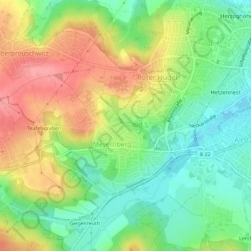
Nome: Mapa topográfico Meyernberg, altitude, relevo.
Local: Meyernberg, Bayreuth, Bayern, Deutschland (49.93002 11.52202 49.94777 11.54867)
Altitude média: 382 m
Altitude mínima: 340 m
Altitude máxima: 436 m
Outros mapas topográficos
Clique em um mapa para visualizar sua topografia, sua altitude e seu relevo.
Bayreuth
Deutschland > Bayern > Bayreuth
Bayreuth, Oberfranken, Bayern, 95444, Deutschland
Altitude média: 377 m
Geiersnest
Deutschland > Bayern > Bayreuth
Geiersnest, Sankt Johannis, Bayreuth, Bayern, 95448, Deutschland
Altitude média: 377 m