
Mapa topográfico Geiersnest
Mapa interativo
Clique no mapa para exibir a altitude.
Sobre este mapa
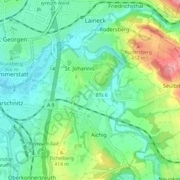
Nome: Mapa topográfico Geiersnest, altitude, relevo.
Altitude média: 377 m
Altitude mínima: 337 m
Altitude máxima: 479 m
Outros mapas topográficos
Clique em um mapa para visualizar sua topografia, sua altitude e seu relevo.
Bayreuth
Deutschland > Bayern > Bayreuth
Bayreuth, Oberfranken, Bayern, 95444, Deutschland
Altitude média: 377 m
Meyernberg
Deutschland > Bayern > Bayreuth
Meyernberg, Bayreuth, Bayern, Deutschland
Altitude média: 382 m