
Mapa topográfico Irlanda
Mapa interativo
Clique no mapa para exibir a altitude.
Sobre este mapa
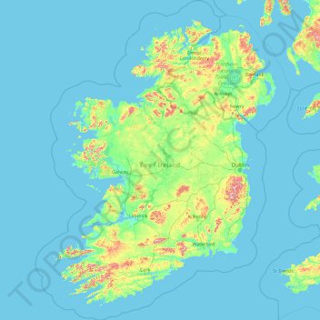
Nome: Mapa topográfico Irlanda, altitude, relevo.
Local: Irlanda (51.22200 -11.01338 55.63600 -5.07778)
Altitude média: 42 m
Altitude mínima: -3 m
Altitude máxima: 832 m
Outros mapas topográficos
Clique em um mapa para visualizar sua topografia, sua altitude e seu relevo.
The Municipal District of Kilkenny City
The Municipal District of Kilkenny City, Condado de Kilkenny, Leinster, Irlanda
Altitude média: 84 m
West Clare Municipal District
West Clare Municipal District, Condado de Clare, Munster, Irlanda
Altitude média: 37 m
The Municipal District of Naas
The Municipal District of Naas, County Kildare, Leinster, Irlanda
Altitude média: 152 m
Oldmilltown
Oldmilltown, Kilteel ED, The Municipal District of Naas, County Kildare, Leinster, Irlanda
Altitude média: 154 m
Churchtown-Orwell ED
Churchtown-Orwell ED, Dublin 14, Dún Laoghaire-Rathdown, County Dublin, Leinster, Irlanda
Altitude média: 54 m
Cherry Orchard
Cherry Orchard, Merchants Quay E ED, Dublin 8, Dublin, County Dublin, Leinster, Irlanda
Altitude média: 25 m