
Mapa topográfico Chapelton of Elsick
Mapa interativo
Clique no mapa para exibir a altitude.
Sobre este mapa
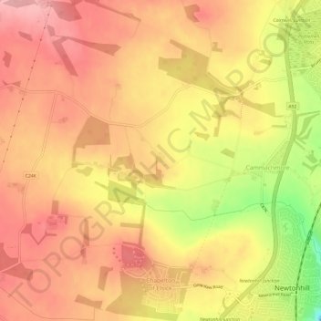
Nome: Mapa topográfico Chapelton of Elsick, altitude, relevo.
Local: Chapelton of Elsick, Aberdeenshire, Scotland, United Kingdom (57.02877 -2.20901 57.06096 -2.16113)
Altitude média: 93 m
Altitude mínima: 4 m
Altitude máxima: 138 m
House styles in Chapelton vary from small apartments to five bedroom family homes. The architecture of the houses' exteriors have slate roof tiles and lime harl. Architectural details and materials in the first phase include slate roofs, timber windows (sash and case to public elevations), Dormer|dormer windows, timber linings to some extensions and garages, corrugated metal roofing, and some properties have working chimneys for wood-burning stoves. A small number of timber buildings with a modern feel are incorporated around the neighbourhood edge.
Outros mapas topográficos
Clique em um mapa para visualizar sua topografia, sua altitude e seu relevo.
Alford
United Kingdom > Scotland > Aberdeenshire
Alford, Aberdeenshire, Scotland, AB33 8PX, United Kingdom
Altitude média: 189 m
Ruthven
United Kingdom > Scotland > Aberdeenshire
Ruthven, Aberdeenshire, Scotland, AB54 4SG, United Kingdom
Altitude média: 132 m
Ben Macdui
United Kingdom > Scotland > Aberdeenshire
Ben Macdui, Aberdeenshire, Scotland, United Kingdom
Altitude média: 1031 m
Braemar
United Kingdom > Scotland > Aberdeenshire
Braemar, Aberdeenshire, Scotland, AB35 5YN, United Kingdom
Altitude média: 445 m
Mintlaw
United Kingdom > Scotland > Aberdeenshire
Mintlaw, Aberdeenshire, Scotland, AB42 5EL, United Kingdom
Altitude média: 48 m
Ballater
United Kingdom > Scotland > Aberdeenshire > Ballater
Ballater, Aberdeenshire, Scotland, AB35 5QD, United Kingdom
Altitude média: 360 m
Banff
United Kingdom > Scotland > Aberdeenshire
Banff, Aberdeenshire, Scotland, AB45 1LE, United Kingdom
Altitude média: 36 m
Inverurie
United Kingdom > Scotland > Aberdeenshire
Inverurie, Aberdeenshire, Scotland, AB51 3SN, United Kingdom
Altitude média: 102 m