
Mapa topográfico Ballater
Mapa interativo
Clique no mapa para exibir a altitude.
Ballater
Ballater (/ˈbælətər/, Scottish Gaelic: Bealadair) is a village in Aberdeenshire, Scotland on the River Dee, immediately east of the Cairngorm Mountains. Situated at an elevation of 213 metres (699 feet), Ballater is a centre for hikers and known for its spring water, once said to cure scrofula. It is home to more than 1500 inhabitants.
Sobre este mapa
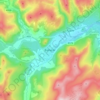
Nome: Mapa topográfico Ballater, altitude, relevo.
Local: Ballater, Aberdeenshire, Scotland, AB35 5QD, United Kingdom (57.00951 -3.08052 57.08951 -3.00052)
Altitude média: 360 m
Altitude mínima: 184 m
Altitude máxima: 645 m