
Mapa topográfico Yang County
Mapa interativo
Clique no mapa para exibir a altitude.
Sobre este mapa
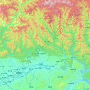
Nome: Mapa topográfico Yang County, altitude, relevo.
Local: Yang County, Hanzhong, Shaanxi, China (33.03786 107.18409 33.72072 108.04555)
Altitude média: 1079 m
Altitude mínima: 398 m
Altitude máxima: 3039 m
Yang County is located in southwestern Shaanxi Province, near Chenggu County and Xixiang County, and is part of the Shannan region. It sits in the eastern Hanzhong Basin, on the Han River. The Daba Mountains are to the south of the county; to the north are the Qin Mountains. The administrative area (prefecture) ranges in latitude from 33°02′ to 33°43′N and in longitude from 107°11′ to 108°33′E, and is 3,206 square kilometres (1,238 sq mi). The northern part of the county generally has a higher elevation, while the southern part is generally lower in elevation. Yang County's lowest point, in the town of Huangjinxia [zh] lies at 389.7 metres (1,279 ft) above sea level. The county's highest point is a mountain called Hurenpingliang (Chinese: 昏人坪梁), in the Qin Mountains, which reaches 3,071 metres (10,075 ft) above sea level in elevation.
Outros mapas topográficos
Clique em um mapa para visualizar sua topografia, sua altitude e seu relevo.
Baihe County
China > Shaanxi > Ankang City
Baihe County, Ankang City, Shaanxi, China
Altitude média: 760 m