
Mapa topográfico Yan'an
Mapa interativo
Clique no mapa para exibir a altitude.
Sobre este mapa
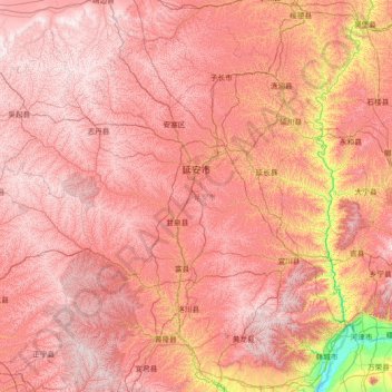
Nome: Mapa topográfico Yan'an, altitude, relevo.
Local: Yan'an, Shaanxi, China (35.35145 107.65051 37.49958 110.54643)
Altitude média: 1186 m
Altitude mínima: 355 m
Altitude máxima: 1819 m
Yan'an is located in northern Shaanxi on the Loess Plateau, with a latitude spanning from 35°21′ to 37°31′ N, and a longitude spanning from 107°41′ t0 110°31′ E. The city is bordered by Yulin to the north, Xianyang, Tongchuan, and Weinan in the Guanzhong region to the south, Linfen and Lüliang of Shanxi to the east across the Yellow River, and Qingyang of Gansu to the west across the Ziwu Ridge (Chinese: 子午岭). The city's elevation is hilly, and is higher in the northwest, and lower in the southeast, ranging from 388 metres (1,273 ft) to 1,809 metres (5,935 ft) above sea level in elevation. The average elevation of Yan'an is approximately 1,000 m (3,280 ft), and Yan'an's urban core has an elevation of about 960 metres (3,150 ft) above sea level. In addition to the Yellow River flowing through Yan'an, the city's major rivers include the Yan River and the Luo River.
Outros mapas topográficos
Clique em um mapa para visualizar sua topografia, sua altitude e seu relevo.
Baihe County
China > Shaanxi > Ankang City
Baihe County, Ankang City, Shaanxi, China
Altitude média: 760 m