
Mapa topográfico Weggis
Mapa interativo
Clique no mapa para exibir a altitude.
Sobre este mapa
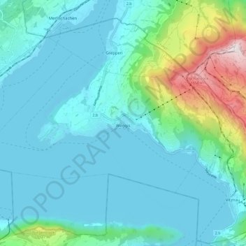
Nome: Mapa topográfico Weggis, altitude, relevo.
Local: Weggis, Lucerne, Switzerland (47.01133 8.36850 47.05469 8.48043)
Altitude média: 651 m
Altitude mínima: 424 m
Altitude máxima: 1791 m
The town of Weggis lies on a south-facing plain on the shore of Lake Lucerne. Formerly, the town consisted of only two communities, Unterdorf in the west and Oberdorf in the east. Because of development in the last decades, new communities have developed: Hinterdorf (east of Oberdorf), Rain and Laugneri (near Hinterdorf), Baumen and Dörfli near Unterdorf, as well as Tischital and Rigiblick on the slope above Oberdorf. The community of Hertenstein (2.3 km (1.4 mi) south-west of the town, on the lake shore) lies in the extreme south-west corner of the municipality, on a peninsula. On the municipal border with Vitznau, 1.9 km (1.2 mi) south-east of the town, another quasi-community has developed. From the lake shore at elevation 436 m (1,430 ft) to an elevation of 794 m (2,605 ft), several hamlets have grown together. They are: Riedsort (on the lake shore), Bannholz (elev. 667 m (2,188 ft)), Bodenberg (elev. 642 m (2,106 ft)), and Sentiberg (elev. 794 m (2,605 ft)). High up the slope, accessible by cog railway and aerial tramway, lies the community of Rigi Kaltbad (2.8 km (1.7 mi) north-east of the town, elev. c. 1,450 m (4,760 ft)). Many other neighborhoods and single farmsteads belong to the municipality.
Outros mapas topográficos
Clique em um mapa para visualizar sua topografia, sua altitude e seu relevo.
Schloss Meggenhorn
Switzerland > Lucerne > Meggen
Schloss Meggenhorn, 53, Meggenhornstrasse, Lerchenbühl, Meggen, Lucerne, 6045, Switzerland
Altitude média: 450 m
Allmendhubel
Switzerland > Lucerne > Menznau
Allmendhubel, Allmend, Menznau, Lucerne, 6122, Switzerland
Altitude média: 636 m
Schachen
Switzerland > Lucerne > Werthenstein > Schachen
Schachen, Werthenstein, Lucerne, 6105, Switzerland
Altitude média: 671 m