
Mapa topográfico Koshi River
Mapa interativo
Clique no mapa para exibir a altitude.
Sobre este mapa
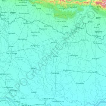
Nome: Mapa topográfico Koshi River, altitude, relevo.
Local: Koshi River, Bihar, India (25.40379 86.43871 26.91017 87.26669)
Altitude média: 82 m
Altitude mínima: 24 m
Altitude máxima: 1960 m
The Kosi River catchment covers six geological and climatic belts varying in altitude from above 8,000 m (26,000 ft) to 95 m (312 ft) comprising the Tibetan plateau, the Himalayas, the Himalayan mid-hill belt, the Mahabharat Range, the Siwalik Hills and the Terai. The Dudh-Koshi sub-basin alone consists of 36 glaciers and 296 glacier lakes. The Kosi River basin borders the Tsangpo River basin in the north, the Mahananda River basin in the east, the Ganges Basin in the south and the Gandaki River basin in the west. The eight tributaries of the basin upstream the Chatra Gorge include from east to west:
Outros mapas topográficos
Clique em um mapa para visualizar sua topografia, sua altitude e seu relevo.
Patna
India > Bihar > Patna Rural
Patna, Patna Rural, Patna District, Bihar, 800001, India
Altitude média: 51 m
Sultanganj
India > Bihar > Sultanganj
Sultanganj, Bhagalpur District, Bihar, 812006, India
Altitude média: 35 m
Parmanandpur
Parmanandpur, Basantpur, Supaul, Bihar, India
Altitude média: 76 m
Gaya
India > Bihar > Gaya Town C.D.Block
Gaya, Gaya Town C.D.Block, Gaya District, Bihar, 823001, India
Altitude média: 111 m
Baruraj (Motipur)
India > Bihar > Baruraj (Motipur)
Baruraj (Motipur), Muzaffarpur, Bihar, 843132, India
Altitude média: 58 m
Manikpur
India > Bihar > Narpatganj
Manikpur, Narpatganj, Araria, Bihar, 854336, India
Altitude média: 70 m