
Mapa topográfico Begusarai
Mapa interativo
Clique no mapa para exibir a altitude.
Sobre este mapa
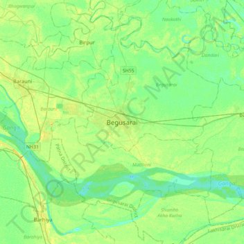
Nome: Mapa topográfico Begusarai, altitude, relevo.
Local: Begusarai, Begusarai District, Bihar, 851117, India (25.25386 85.97489 25.57386 86.29489)
Altitude média: 41 m
Altitude mínima: 32 m
Altitude máxima: 55 m
Begusarai is located at 25°25′N 86°08′E / 25.42°N 86.13°E / 25.42; 86.13. It has an average elevation of 41 metres (134 feet). Begusarai lies in North Bihar and is surrounded by Khagaria in the northeast, Munger in the southeast, Patna in the west, and Samastipur in the northwest.
Outros mapas topográficos
Clique em um mapa para visualizar sua topografia, sua altitude e seu relevo.