
Mapa topográfico Village of Mamaroneck
Mapa interativo
Clique no mapa para exibir a altitude.
Village of Mamaroneck
Other areas of the town include Heathcote Hill, overlooking the harbor, Harbor Heights (the heights) to the northeast, Old Rye Neck (settled in the 1880s), Rye Neck (settled in the 1920s and 1930s), Orienta, and Washingtonville, better known as "The Flats", due to the flat, low-lying topography of the area.
Sobre este mapa
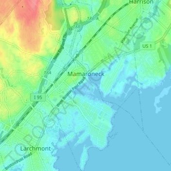
Nome: Mapa topográfico Village of Mamaroneck, altitude, relevo.
Altitude média: 15 m
Altitude mínima: -3 m
Altitude máxima: 65 m
Outros mapas topográficos
Clique em um mapa para visualizar sua topografia, sua altitude e seu relevo.
Ward Pound Ridge Reservation
United States > New York > Westchester County > Town of Pound Ridge
Altitude média: 164 m
Riveredge Trailer Park
United States > New York > Westchester County > Town of Cortlandt > Verplanck
Altitude média: 14 m
Isle of San Souci
United States > New York > Westchester County > City of New Rochelle
Altitude média: 7 m
Wykagyl Park
United States > New York > Westchester County > City of New Rochelle
Altitude média: 41 m
Lake Waccabuc
United States > New York > Westchester County > Town of Lewisboro > Waccabuc
Altitude média: 173 m
Sherman Park
United States > New York > Westchester County > Town of Mount Pleasant > Thornwood
Altitude média: 133 m
Salem Center
United States > New York > Westchester County > Town of North Salem
Altitude média: 147 m
Bonnie Crest
United States > New York > Westchester County > City of New Rochelle
Altitude média: 58 m
West Harrison Village Green
United States > New York > Westchester County > Town/Village of Harrison > East White Plains
Altitude média: 79 m
Sedge Island
United States > New York > Westchester County > City of New Rochelle
Altitude média: 47 m
Crestwood Gardens
United States > New York > Westchester County > City of Yonkers
Altitude média: 65 m
Jefferson Valley
United States > New York > Westchester County > Jefferson Valley-Yorktown
Altitude média: 178 m
Fenmore Park
United States > New York > Westchester County > Town/Village of Harrison
Altitude média: 38 m
Shore Acres
United States > New York > Westchester County > Village of Mamaroneck
Altitude média: 11 m
Bronxville Heights
United States > New York > Westchester County > City of Yonkers
Altitude média: 63 m
Mount Hope
United States > New York > Westchester County > Village of Hastings-on-Hudson
Altitude média: 60 m
New York, Westchester and Boston Railway
United States > New York > Westchester County > Village of Pelham > North Pelham
Altitude média: 28 m
Sleepy Hollow Manor
United States > New York > Westchester County > Village of Sleepy Hollow > Sleepy Hollow Manor
Altitude média: 41 m
Spring Valley
United States > New York > Westchester County > Town of Ossining > Ossining > Spring Valley
Altitude média: 115 m
Sarles Corners
United States > New York > Westchester County > Town of Pound Ridge
Altitude média: 141 m
Secor Gardens
United States > New York > Westchester County > Village of Scarsdale
Altitude média: 70 m