
Mapa topográfico Gunther Park
Mapa interativo
Clique no mapa para exibir a altitude.
Sobre este mapa
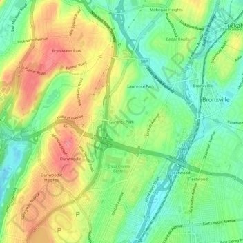
Nome: Mapa topográfico Gunther Park, altitude, relevo.
Altitude média: 56 m
Altitude mínima: 17 m
Altitude máxima: 106 m
Outros mapas topográficos
Clique em um mapa para visualizar sua topografia, sua altitude e seu relevo.
Cecil Park
United States > New York > Westchester County > City of Yonkers
Cecil Park, City of Yonkers, Westchester County, New York, 10707, United States
Altitude média: 70 m
Park Hill
United States > New York > Westchester County > City of Yonkers
Park Hill, City of Yonkers, Westchester County, New York, 10705, United States
Altitude média: 43 m
Colonial Heights
United States > New York > Westchester County > City of Yonkers
Colonial Heights, City of Yonkers, Westchester County, New York, 10710, United States
Altitude média: 60 m
Grey Oaks
United States > New York > Westchester County > City of Yonkers
Grey Oaks, City of Yonkers, Westchester County, New York, 10703, United States
Altitude média: 60 m
Lowerre
United States > New York > Westchester County > City of Yonkers
Lowerre, City of Yonkers, Westchester County, New York, 10705, United States
Altitude média: 34 m
Crestwood Gardens
United States > New York > Westchester County > City of Yonkers
Crestwood Gardens, City of Yonkers, Westchester County, New York, 10707, United States
Altitude média: 65 m
Bronxville Heights
United States > New York > Westchester County > City of Yonkers
Bronxville Heights, City of Yonkers, Westchester County, New York, 10710, United States
Altitude média: 63 m
Nepperhan
United States > New York > Westchester County > City of Yonkers
Nepperhan, City of Yonkers, Westchester County, New York, 10703, United States
Altitude média: 64 m