
Mapa topográfico Roslin
Mapa interativo
Clique no mapa para exibir a altitude.
Sobre este mapa
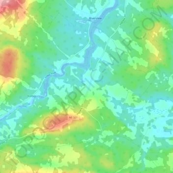
Nome: Mapa topográfico Roslin, altitude, relevo.
Altitude média: 34 m
Altitude mínima: -6 m
Altitude máxima: 127 m
Outros mapas topográficos
Clique em um mapa para visualizar sua topografia, sua altitude e seu relevo.
Nappan
Canada > Nova Scotia > Municipality of the County of Cumberland
Nappan, Municipality of the County of Cumberland, Cumberland County, Nova Scotia, B0L 1C0, Canada
Altitude média: 25 m
Lorneville
Canada > Nova Scotia > Municipality of the County of Cumberland
Lorneville, Municipality of the County of Cumberland, Cumberland County, Nova Scotia, B4H 3X9, Canada
Altitude média: 20 m
Rockley
Canada > Nova Scotia > Municipality of the County of Cumberland
Rockley, Municipality of the County of Cumberland, Cumberland County, Nova Scotia, B0M 1V0, Canada
Altitude média: 24 m
Wentworth Provincial Park
Canada > Nova Scotia > Municipality of the County of Cumberland > Wentworth Station
Wentworth Provincial Park, Valley Road, Wentworth Station, Wentworth, Municipality of the County of Cumberland, Cumberland County, Nova Scotia, B0M 1Z0, Canada
Altitude média: 81 m
Isle Haute
Canada > Nova Scotia > Municipality of the County of Cumberland
Isle Haute, Municipality of the County of Cumberland, Cumberland County, Nova Scotia, Canada
Altitude média: 1 m
Fenwick
Canada > Nova Scotia > Municipality of the County of Cumberland
Fenwick, Municipality of the County of Cumberland, Cumberland County, Nova Scotia, B0L 1C0, Canada
Altitude média: 79 m